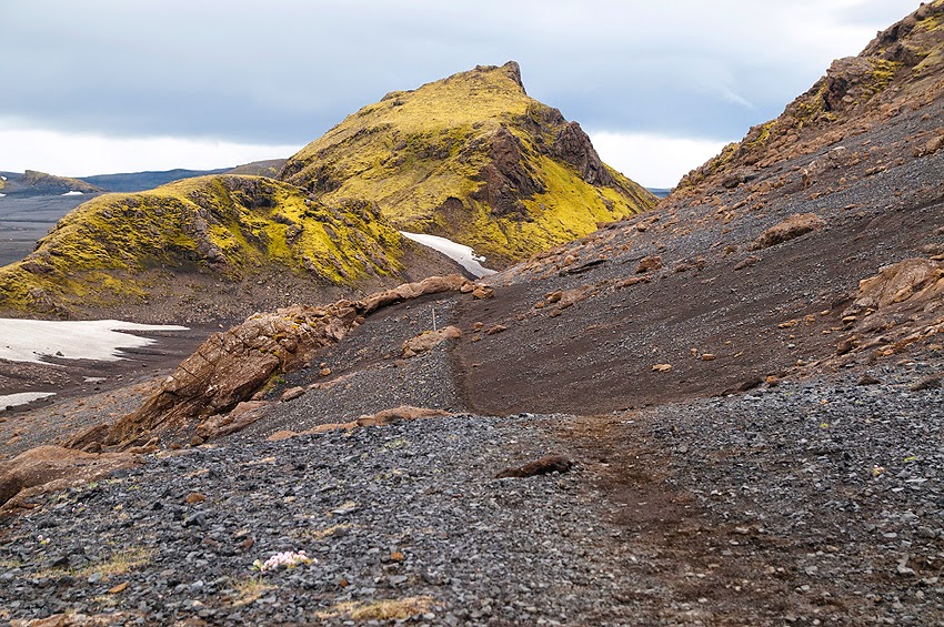
szczegolowe informacje dotyczace treku laugavegur
detailed info regarding laugavegur trek

dlugosc treku landmannalaugar -thorsmork okolo 53km
trasa zajmuje od 2-5 dni (najczesciej 4 dni)
mozliwosc przedluzenia treku o dodatkowe 25km thorsmork -skogar (najczesciej 2 dni)
szlak otwarty: polowa czerwca do poczatku wrzesnia
oficjalna strona
.
.
trek from landmannalaugar to thorsmork 53km / 36miles
walked between 2-5 days, usually 4 days
option to extend the walk from thorsmork to skogar, additional 25km (usually walked over 2 days)
tracks open mid june to beginning of September
official website

etap 1 / stage 1 landmannalaugar - hrafntinnusker 12km/8miles
Distance 12 km, estimated walking time 4 - 5 hours. Elevation increase 470 meters. From the hut in Landmannalaugar (75 persons, GPS 63°59.600 - 19°03.660) the trail goes through a rough lavafield "Laugahraun". From there on up the slopes of "Brennisteinsalda" and to the plateau. The view offers an incredible spectrum of colours. After 3 - 4 hours you arrive at "Stórihver", a hot spring and almost the only green spot visible in the first day. In most years the rest of the trail from "Stórihver" to "Höskuldsskáli" hut is covered with snow. Chances of fog are very high so even though the trail is clearly marked you must be careful. A walk to the icecaves (approx. 1.5km from the hut) is a must. The huts location GPS 63°55.840 - 19°09.700 and sleeps 36 persons.
huts:
landmannalaugar http://www.nat.is/fjallaskalareng/skalar_fi_landmannalaugar.htm

etap 2 / stage 2 hrafntinnusker - alftavatn 12km /8miles
Distance 12 km, estimated walking time 4 - 5 hours. Elevation decrease 490 m. The first part of the trail takes us through a valley with some small ravines but be careful as they may be filled with snow. If the visibility is good a walk up to the top of mountain "Háskerðingur" (1281 m) will reward your with a breathtaking view. Soon we leave the colourful rhyolite mountains and enter an area with dark palagonite mountains and glaciers. You will also notice a considerable increase in vegetation. The trail down the "Jökultungur" is rather steep but leads down to a friendly oasis on the banks of river "Grashagakvísl" a fine place to rest for a while. From there on the trail to the two huts by the lake "Álftavatn" is on flat land. There are two huts (58 persons, GPS 63°51.470 - 19°13.640).
huts:

etap 3 / stage 3 alftavatn - emstrur (botnar) 15km /9miles
Distance 15 km., estimated walking time 6-7 hrs., elevation decrease 40 m. The trail takes us over the ridge "Brattháls" into "Hvanngil" ravine, wading across the river "Bratthálskvísl". In "Hvanngil" are two huts, one built for sheepherders in 1963 and one for tourists, built in 1995. A short walk from the huts is the river "Kaldaklofskvísl" with a bridge for hikers. On the eastern bank of "Kaldaklofskvísl" the trail branches, one branch leading eastwards to "Mælifellssandur" (Road F 210) but the other one southwards to "Emstrur" and we choose the latter. Less than one km from "Kaldaklofskvísl" another river has to be waded and approximately 4 km further we come to the river "Nyrðri Emstruá" but this time there is a bridge to cross it. Soon we will be overlooking the huts in "Botnar" (40 persons, GPS 63°45.980 - 19°22.480). A fine walk in the evening is to the "Markarfljótsgljúfur" canyon.
huts:
emstrur (botnar) http://www.nat.is/fjallaskalareng/skalar_fi_botnar_emstrur.htm

etap 4 / stage 4 emstrur (botnar) - thorsmork
Distance 15 km., estimated walking time 6-7 hrs., elevation decrease 300 m. First we have to go around the canyon of "Syðri - Emstruá" and there is a very steep path down to the bridge so be careful. Then a walk through the area known as "Almenningar" with crossing of among other rivers "Þröngá". It is good practice when wading to go hand in hand and head downstream. After crossing "Þröngá" a 30 minutes walk takes us to the hut in "Langidalur" in "Þórsmörk" (75 persons, GPS 63°40.960 - 19°30.890) Landscape and vegetation is changing rapidly. Birchwood and all kinds of plants a welcome change after the desert now behind us. The hut in Thorsmork is Basar huts in Godaland, in Langidalur Hut Skagfjordsskáli and
cottages and huts in Husadalur.
cottages and huts in Husadalur.
huts
emstrur (botnar ) http://www.nat.is/fjallaskalareng/skalar_fi_botnar_emstrur.htm
OPCJONALNIE / OPTIONAL
dodatkowe 25km pomiedzy thorsmork I skogar
optymalny czas przejscia 2 dni
nocleg - schronisko fimmvorduhals
.
.
additional 25km from thorsmork to skogar
usually walked over 2 days
sleep at fimmvorduhals hut
fimmvorduhals hut http://www.nat.is/fjallaskalareng/skalar_utivistar_fimmvorduhals.htm
linki do zdjec z tego odcinka / links to pic galleries
H U T S
LANDMANNALAUGAR
The Iceland Touring Association first built a hut in Landmannalaugar in 1951, but the present hut dates back to 1969. The huts are located about 600 metres above mean sea level at the edge of the lavafield Laugahraun on a few hot springs, which create excellent bathing conditions in a natural brook.
The dwelling hut is two storeys high. The ground floor comprises a spacey entry, a large sleeping hall, a kitchen, the warden's quarters and a storage room. Upstairs are three large sleeping rooms and one small. The house is heated the whole year round and gas is used for cooking. All neccessary appliances are in the kitchen. Outside is a large house with WC and showers. The camping site is to the northeast of the houses.
Landmannalaugar is either the beginning or the end of the hiking trail to or from Thorsmork. All around the houses are unbelievably beautiful hiking trails, short and long.
The telephone number of the hut from July 1st to September 30th is: 860-3335
GPS co-ordinates: 63°59.600 19°03.660.
Source: The ITA website. fi@fi.is Tel.: 568 2533
The dwelling hut is two storeys high. The ground floor comprises a spacey entry, a large sleeping hall, a kitchen, the warden's quarters and a storage room. Upstairs are three large sleeping rooms and one small. The house is heated the whole year round and gas is used for cooking. All neccessary appliances are in the kitchen. Outside is a large house with WC and showers. The camping site is to the northeast of the houses.
Landmannalaugar is either the beginning or the end of the hiking trail to or from Thorsmork. All around the houses are unbelievably beautiful hiking trails, short and long.
The telephone number of the hut from July 1st to September 30th is: 860-3335
GPS co-ordinates: 63°59.600 19°03.660.
Source: The ITA website. fi@fi.is Tel.: 568 2533
HRAFNTINNUSKER
The ITA hut on Mt Hrafntinnusker, Hoskuldarskali, was built in 1977 at 1027 metres above mean sea level. Among attractions in its vicinity are the ice caves. The hut comprises the ground floor with a kitchen and sleeping hall, and the attic with 18 mattresses and the quarters of the warden. The hut accommodates 36 people on both floors, but during bad weather spells, the warden permits people to sleep wherever there is space.
The house is geothermally heated the whole year round and during the presence of the warden, usually during July and August, running, cold water is supplied in the kitchen. Other times of the year, water has to be fetched from the gully west of the hut or snow has to be melted. Electricity is supplied by solar cells. The switch is in the entrance and the electrical supplies last 6 hours after it has been turned on. Each lamp has switches. The water pump is also connected to the electrical system. Visitors are kindly asked to economize. The gas stoves in the kitchen are connected to gas containers the whole year round.A two-way emergency radio is located in the entrance.
The latrine is in the immediate proximity of the hut. The winter latrine is inside the hut. The kitchen contains all necessary equipment, pots, pans, cutlery, plates, glasses etc. Sometimes the electrical system fails and technicians have to travel 200 km to repair it, and sometimes the mountain tracks are snowed in and do not allow access.
Peace and quiet is expected between midnight and 07;00 in the morning, unless the warden decides otherwise. The use of the kitchen during the night is prohibited. Smoking inside the hut is forbidden.
The environment of the hut is sand, which gets carried into it if its guests do not wipe their feet carefully before entering. Shoes should be left in the entrance and house shoes should be brought along. Guests are kindly asked to help the warden to keep the hut clean and tourist guides should emphasize this fact. During the ten months without a warden, guests must leave a clean hut behind after use. The camping site is down below the hut and a water tab nearby allows access to water. Visitors and guests are required to take all rubbish with them to containers at the huts in Landmannalaugar or on lake Alftavatn. Please do not throw rubbish into the latrines or put it under a stone.
The operation of this hut is expensive. Therefore it is essential that guests pay for its use. ITA publishes its rates annually. During the presence of the warden, he/she collects the fees, but outside that period, guests are asked to leave the money in the box in the entrance.
The house is geothermally heated the whole year round and during the presence of the warden, usually during July and August, running, cold water is supplied in the kitchen. Other times of the year, water has to be fetched from the gully west of the hut or snow has to be melted. Electricity is supplied by solar cells. The switch is in the entrance and the electrical supplies last 6 hours after it has been turned on. Each lamp has switches. The water pump is also connected to the electrical system. Visitors are kindly asked to economize. The gas stoves in the kitchen are connected to gas containers the whole year round.A two-way emergency radio is located in the entrance.
The latrine is in the immediate proximity of the hut. The winter latrine is inside the hut. The kitchen contains all necessary equipment, pots, pans, cutlery, plates, glasses etc. Sometimes the electrical system fails and technicians have to travel 200 km to repair it, and sometimes the mountain tracks are snowed in and do not allow access.
Peace and quiet is expected between midnight and 07;00 in the morning, unless the warden decides otherwise. The use of the kitchen during the night is prohibited. Smoking inside the hut is forbidden.
The environment of the hut is sand, which gets carried into it if its guests do not wipe their feet carefully before entering. Shoes should be left in the entrance and house shoes should be brought along. Guests are kindly asked to help the warden to keep the hut clean and tourist guides should emphasize this fact. During the ten months without a warden, guests must leave a clean hut behind after use. The camping site is down below the hut and a water tab nearby allows access to water. Visitors and guests are required to take all rubbish with them to containers at the huts in Landmannalaugar or on lake Alftavatn. Please do not throw rubbish into the latrines or put it under a stone.
The operation of this hut is expensive. Therefore it is essential that guests pay for its use. ITA publishes its rates annually. During the presence of the warden, he/she collects the fees, but outside that period, guests are asked to leave the money in the box in the entrance.
Geographical co-ordinates (WGS-84): 63.933261 19.168080.UTM (WGS-84): 7090867.1 7589807.4.Geographical co-ordinates (Hjörsey 1955): 63.933571 19.168477
UTM ( Hjörsey1955): 7091076.0 75897691.6
Source: The ITA website. fi@fi.is
UTM ( Hjörsey1955): 7091076.0 75897691.6
Source: The ITA website. fi@fi.is
Tel.: 568 2533:
Hut Hrafntinnusker (lat="63.935368" lon="-19.167315"):
Garbage collection: No
Showers: No
Flush toilets: No
Location: On the mountain side
ALFTAVATN
The mountain huts of the Iceland Touring Association on lake Alftavat on the Middle Route were built in 1979 and can accommodate 58 people in sleeping bags. They are equipped with gas stoves, utensils and running cold water. One of the huts is reserved for hikers on the trail between Thorsmork and Landmannalaugar.
During summer, the warden of the huts lives in a separate house. Showers and WCs are in the fourth house and fee is charged for the use of the showers. The huts are about half-way on the trail and the Middle Route for vehicles is only a stone's throw away. The beautiful landscapes of the area offer varied hikes, i.e. to the gorge Alftaskard, Bratthals and Torfahlaup.
Lake Alftavatn is deep and decorative. In the past, whooper swans were hunted there, but after the drowning of the farmer of Fljotsdalur in 1838, witnessed by his teenage daughter, the hunt was abandoned. It is possible to drive (4x4) along Mt. Torfatindur to the narrow gorge Torfahlaup.
GPS coordinates: 63°51.470 19°13.640
Source: The ITA website. fi@fi.is Tel.: 568 2533
During summer, the warden of the huts lives in a separate house. Showers and WCs are in the fourth house and fee is charged for the use of the showers. The huts are about half-way on the trail and the Middle Route for vehicles is only a stone's throw away. The beautiful landscapes of the area offer varied hikes, i.e. to the gorge Alftaskard, Bratthals and Torfahlaup.
Lake Alftavatn is deep and decorative. In the past, whooper swans were hunted there, but after the drowning of the farmer of Fljotsdalur in 1838, witnessed by his teenage daughter, the hunt was abandoned. It is possible to drive (4x4) along Mt. Torfatindur to the narrow gorge Torfahlaup.
GPS coordinates: 63°51.470 19°13.640
Source: The ITA website. fi@fi.is Tel.: 568 2533
Hut Álftavatn (lat="63.856522" lon="-19.227863"):
Garbage collection: Yes
Showers: Yes
Flush toilets: Yes
Location: Next to a lake
HVANNGIL
The new Hvanngil Hut offers sleeping bag accommodations for 70 people in four rooms. The warden’s telephone number is 853 9081. The Midvegur Route starts at the farm and church site Keldur with its ancient farm houses and Folk Museum. The road continues across the Langviu Lava Field, River Markarfljot and past Lake Alftavatn, where there are two of the Icelandic Touring Association’s huts for the hikers on the “Laugavegur Hiking Trail”.
GPS co-ordinates: 64°50.026 19°12.507. fi@fi.is
GPS co-ordinates: 64°50.026 19°12.507. fi@fi.is
EMSTRUR (BOTNAR)
The Iceland Touring Association huts Botnar on river South Emstrua accommodate 40 people. They are equipped with gas stoves, utensils and running cold water. One of the huts is reserved for hikers on the trail between Thorsmork and Landmannalaugar.
During summer, the warden of the huts lives in a separate house. Showers and WCs are in the fourth house and fee is charged for the use of the showers. The huts are about half-way on the trail Just south of the huts is a pedestrian bridge across the aforementioned river.
A short and rewarding walk takes you to the canyons of river Markarfljot and a mountain track allows 4wd-vehicles access to the huts.
GPS co-ordinates: 63°45.980 19°22.450.
Source: The ITA website. fi@fi.is Tel.: 568 2533
During summer, the warden of the huts lives in a separate house. Showers and WCs are in the fourth house and fee is charged for the use of the showers. The huts are about half-way on the trail Just south of the huts is a pedestrian bridge across the aforementioned river.
A short and rewarding walk takes you to the canyons of river Markarfljot and a mountain track allows 4wd-vehicles access to the huts.
GPS co-ordinates: 63°45.980 19°22.450.
Source: The ITA website. fi@fi.is Tel.: 568 2533
Hut Emstrur (lat="63.767708" lon="-19.373541"):
Garbage collection: No
Showers: Yes
Flush toilets: Yes
Location: On a slope near the valley
THORSMORK - HUSADALUR
The Volcano Huts are located in the Thorsmork nature reserve in Iceland, situated in the Husadalur valley, between towering glaciers and volcanoes. The area can best be described as a hikers paradise where you will find endless hiking trails that lead you through beautiful, volcanic landscapes. Here you will experience Icelandic nature at its best and meet interesting people that share your passion for nature and adventure.
Accommodation
The Volcano Huts offer accommodation in small cottages, shared cabin-dorms, private bedrooms and camping grounds surrounded by unique volcanic nature. Whether you are travelling by yourself, with your family or with a group, you should find a suitable accommodation at the Volcano Huts.
Accommodation and other services can be booked through our website www.volcanohuts.com.
Services at the Volcano Huts
Restaurant The LavaGrill is the heart of the Volcano Huts and offers rich and hearty meals, prepared with love and Icelandic ingredients. We offer breakfast, lunch and dinner, homemade cakes and coffee. We can also send you off with a packed lunch or a picnic basket. The bar offers a selection of local beers and cocktails.
Food: The LavaGrill is the heart of the Volcano Huts and offers rich and hearty meals, prepared with love and Icelandic ingredients. We offer breakfast, lunch and dinner, homemade cakes and coffee. We can also send you off with a packed lunch or a picnic basket. The bar offers a selection of local beers and cocktails.
Here, you can linger in the LavaSPA natural hot pool and sauna, read a book from our library or exchange stories with other travelers around the campfire. We have a small playground for the youngest generation and we have trunks, full of toys such as Frisbees, footballs, crocket sets and other fun stuff for people of all ages.
THORSMORK - GODALAND -BASAR
Soon after the Touring Association Utivist was founded, its members started contemplating the construction of its first mountain hut in the Godaland area. A hut there would increase the savety of travellers and facilitate the access to numerous remarkable hiking areas. The Basar area was mostly intact, only shepherds and a few other people from the nearby counties had visited this nature paradise.
The large hut was built during the period 1980-1981, and the smaller one shortly afterwards. In the middle of the nineties, a large kitchen and dining hall were added to the large hut. Immediately after the Utivist settlement in Basar, the development of the camping grounds commenced.
Ever since volunteers have continued working at maintainance and improvements. The association has published hiking maps with explanations. The Godaland area comprises a number of hiking possibilities, short and long, easy and more strenuous, if people want to conquer the mountain peaks. During summer, summer is pipelined to the huts and the WC are open. The huts are heated with oil and a small hydroelectric power station supples electricity for lights. The huts accommodate 80-90 people. Wardens are present from early May to October.
GPS co-ordinates: N63°40,559' W19°29,014'. Source: Utivist website.
Tel.: 562 1000 head office in ReykjavikBasar Tel.: 893-2910
Camping Isk. 1100.- per persons
The large hut was built during the period 1980-1981, and the smaller one shortly afterwards. In the middle of the nineties, a large kitchen and dining hall were added to the large hut. Immediately after the Utivist settlement in Basar, the development of the camping grounds commenced.
Ever since volunteers have continued working at maintainance and improvements. The association has published hiking maps with explanations. The Godaland area comprises a number of hiking possibilities, short and long, easy and more strenuous, if people want to conquer the mountain peaks. During summer, summer is pipelined to the huts and the WC are open. The huts are heated with oil and a small hydroelectric power station supples electricity for lights. The huts accommodate 80-90 people. Wardens are present from early May to October.
GPS co-ordinates: N63°40,559' W19°29,014'. Source: Utivist website.
Tel.: 562 1000 head office in ReykjavikBasar Tel.: 893-2910
Camping Isk. 1100.- per persons
THORSMORK - SKAGFJORDSKALLI
Mountain hut Skagfjordsskali is located on a flat area at the mouth of Valley Langidalur in Thorsmork, just a stone's throw from river Krossa. The route there from road # 1 requires jeeps or other robust 4wd vehicles, great care and experience, because of the many unbridged rivers which have to be forded.
Among the many attractions enroute are the gorge Stakkholtsgja and a few others. Just outside the hut is Mt Valahnukur, which tempts most people to climb and nearby attractions, Storendi, Stangarhals, Hamraskogar, Husadalur, Tindafjoll, Basar, Eyjafjallajokull and many others, offer great hiking possibilities. Here is also the starting or ending point of the socalled "Laugavegur" hiking trail between Thorsmork and Landmannalaugar. Hikers on that trail spend nights in the ITA huts in Emstrur, on lake Alftavatn and Mt. Hrafntinnusker.
On the groundfloor of the hut are a spaceous entrance, two small kitchens, a big dining hall, and two sleeping halls with bunks. In the attic are more bunks. The hut accommodates 75 people. Outside are separate houses, one with WC and showers, a pick-nick house for day visitors, small sleeping quarters (2-4), and a shop. The hut is heated by an oil furnace, which is also used for cooking. All necessary appliances can be found in the kitchens.
The telephone numbers of the hut from May 15th and September 30th are: 854-1191 & 893-1191.
GPS co-ordinates: 63°40.960 19°30.890. fi@fi.is Tel.: 568 2533
Among the many attractions enroute are the gorge Stakkholtsgja and a few others. Just outside the hut is Mt Valahnukur, which tempts most people to climb and nearby attractions, Storendi, Stangarhals, Hamraskogar, Husadalur, Tindafjoll, Basar, Eyjafjallajokull and many others, offer great hiking possibilities. Here is also the starting or ending point of the socalled "Laugavegur" hiking trail between Thorsmork and Landmannalaugar. Hikers on that trail spend nights in the ITA huts in Emstrur, on lake Alftavatn and Mt. Hrafntinnusker.
On the groundfloor of the hut are a spaceous entrance, two small kitchens, a big dining hall, and two sleeping halls with bunks. In the attic are more bunks. The hut accommodates 75 people. Outside are separate houses, one with WC and showers, a pick-nick house for day visitors, small sleeping quarters (2-4), and a shop. The hut is heated by an oil furnace, which is also used for cooking. All necessary appliances can be found in the kitchens.
The telephone numbers of the hut from May 15th and September 30th are: 854-1191 & 893-1191.
GPS co-ordinates: 63°40.960 19°30.890. fi@fi.is Tel.: 568 2533
Hut Lansidalur ("63.684612" lon="-19.512304"):
Garbage collection: Yes
Showers: Yes
Flush toilets: Yes
Location: By the river
dla tych, ktorzy maja ochote na wiecej / if you still don't have enough..
RI V E R C R O S S I N G S
Get out early. Cooler overnight and morning temperatures mean that the volume of snowmelt is lower early in the day, which means that streams will flow more slowly. Thunderstorms are also more common in afternoon and make currents more treacherous.
At the Crossing• Assess the situation. The actual point where a trail meets a river may not be the best place to get to the other side. Scout the river (ideally from an elevated perspective) or look both up- and downstream for alternatives. If you can't identify a safe crossing location, then don't take the risk and turn around. Wishful thinking has no place in this decision, so be conservative and assume the worst. Invariably, streams are faster and deeper than they appear.
• Straight. Wide. Shallow. That's what you're looking for when identifying a place to cross.
• Watch out for debris. If the river is carrying a lot of debris, such as branches and small logs, it's not a good idea to cross. The debris is an indication that stream flows are high. And objects flowing downstream can create a serious hazard if they strike you as you're crossing.
• Look for braided channels. The crossing may be wider where a river breaks into separate channels. But the current's intensity will be dissipated and there may also be small islands or gravel bars where you can take a break and plot your next steps.
• Test the current. Toss a branch and watch how swiftly it moves downstream. That will give you a better sense of the direction of the main current and how fast it's moving.
• Don't cross where flows are much above your knees. Even comparatively shallow water can knock you off balance and carry you downstream if it's flowing rapidly enough. The only time to wade through deeper water is when you locate a flat pool with little or no current.
• Loosen your pack before crossing. Undo your waist belt and let out the shoulder straps so that it's easier to remove. If you fall in and your pack gets soaked, it can drag you down or get snagged. You might lose your pack but consider the alternative.
• Look for low and open exit points on the opposite bank. Once you reach the other side, you'll want to be able to get out of the stream as quickly as possible. A scramble up a steep bank could lead to a slip that puts you right back into the stream.
Crossing the Stream
• Face Upstream and Shuffle Sideways. Slide your feet along the bottom while facing the river. Angle yourself diagonally to the flow and move in a slightly downstream direction toward the opposite bank.
• Always maintain two points of contact with the bottom. Use your poles to steady yourself as you shift your feet. The more contact you have with the bottom, the more stable you'll be.
• There's strength in numbers. Crossing with a partner or with a group of people creates additional stability. Link arms and coordinate your movements.
(source http://hiking.about.com/od/hiking-safety-advice/a/Hiking-Safety-How-To-Cross-A-River.htm)
more info on river crossing
S P R Z E T / G E A R
The following gear is essential, no matter how warm it is on the day of departure.• Hiking boots: should be comfortable and well broken in. Raincoat / waterproof jacket, over trousers (wind and water proof) and a woollen had should be taken everywhere in Iceland. Sunglasses are recommended in early summer due to extended snowfields on the track.
• Pack: should be supplied with large waterproof/plastic liner
• Sleeping bag: has to be carried of all guests. Campers need good quality down or hollofil bag as temperatures can drop to 0°C even in midsummer.
• Campers: need to bring all cooking gear as they cannot use the kitchen facilities of the huts.
• Campers: tents should be wind- and weatherproof with attached strings to secure it in case of extreme winds
• Toilet paper is supplied at each of the huts.
• First aid kit: sunscreen, blister kits, pain relief, assorted bandages
• Survival Kit: survival blanket, whistle, paper, pencil, high energy snack food
• Drink bottle: 1 - 2 litre capacity (you need to drink regularly during the day). No water filter equipment is needed.
• Optional extras: GPS navigation device/compass and map, camera, lightweight shoes for in hut and river crossings, hiking poles for steep descents and river crossings, ear plugs for communal bunkrooms (you will be sharing huts with up to 70 hikers).
• Swimwear: is only necessary for the hot spring in Landmannalaugar. Hot springs will be crossed elsewhere on the Laugavegur but are unfortunately too hot and small to bath in. A little shop with the most essential food can be found during high season in Landmannalaugar and Þórsmörk Langidalur. Apart from that, no food can be purchased along the track.
more info
ROZKLADY JAZDY AUTOBUSOW / BUS TIMETABLES
bus hiking passes
ISLANDIA -OGOLNE INFO / ICELAND -GENERAL INFO
kampingi w islandii / campsites in Iceland
stacje benzynowe N1 / N1 petrol stations
ONLINE MAPS
national land survey Iceland
very detailed / interactive
some online / pdf maps
GALERIE ZE ZDJECIAMI I BLOGI / PICTURE GALLERIES AND BLOGS
91 days in Iceland blog & gallery (very useful)
crossing Iceland by Alastair Humphreys
every trail - laugavegur
landmannalaugar info -OFFICIAL
laugavegur trek description
landmannalaugar weather forecast website
nasze podroze -islandia (gallery)
zlap trop blog (in Polish)
a year in fire and ice blog
rough guides -laugavegur
laugavegurin OFFICIAL
laugavegur gallery
forum Iceland (in Polish)
photo voyage blog (in French)
vegagerdin - transport / roads info OFFICIAL
Iceland virtual tour
WEBCAMS
landmannalaugar
various locations
10 locations
LANGUAGE
common greetings in Icelandic
CULTURE
Icelandic music
radio stations
MOUNTAIN / GLACIER GUIDES
AERIAL TOURS